| TWENTY YEARS PREDICTION |
| The interpolated mean EC values per landform and relief units are given in table 1. A similar trend as depicted in the measured values and the tenth year prediction is exhibited, where the highest values occur in the floodplain and new terraces and the lowest in the ridges in both zones. The only difference is that the values have now increased particularly for the root-zone, but not much for the transition zone. Instead some relief units have shown an insignificant decrease in the transition zone as compared to the previous decade. |
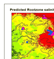
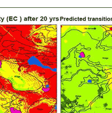
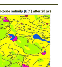
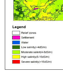
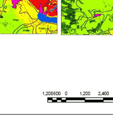
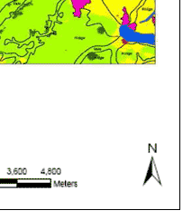
| The estimated areas that would be affected in the twentieth year in total area are given in table 2. show the reclassified EC maps which were produced from interpolation of simulated values using universal kriging. The maps (figure1. )clearly indicate how potentially affected areas are distributed over the study area. From these maps it�s clear that the salinity distribution follows the same pattern as with the previous cases, with low salinity occurring along the south western part and progressively increases in the opposite direction resulting in highly saline areas occurring in the north eastern side. This pattern indicates the effect of physiographic condition to salinity as the major part of the south western side is dominated by ridges and the north eastern side by the flood plains and lateral vales as well as terraces. This kind of pattern can also be associated with land use types as the latter side is dominated by paddy rice while south western side mainly cassava and maize are produced. |
| Zone |
Total are (ha) |
Percentage area per salinity level |
| Low Salinity |
Moderate |
High Salinity |
Severe Salinity |
| ECe (dS/m) |
0 - 4 |
4 - 8 |
8 - 16 |
> 16 |
| Root -zone |
22725 |
6.74 |
32.36 |
43.37 |
17.53 |
| Transition zone |
4.21 |
59.58 |
36.21 |
0.00 |
|
| Relief Unit |
Total are (ha) |
Percentage area per salinity level |
| Low Salinity |
Moderate |
High Salinity |
Severe Salinity |
| ECe (dS/m) |
0 - 4 |
4 - 8 |
8 - 16 |
> 16 |
| Floodplain |
74450 |
0.00 |
8.19 |
88.68 |
3.12 |
| Glacis |
2106.75 |
1.66 |
41.51 |
56.62 |
0.21 |
| Lateral Vale |
3254.50 |
0.02 |
11.45 |
88.04 |
0.49 |
| New Terraces |
119.00 |
0.00 |
3.78 |
87.61 |
8.61 |
| Old Terraces |
556.75 |
0.85 |
62.24 |
36.24 |
0.67 |
| Ridge |
12994.50 |
6.04 |
72.56 |
21.35 |
0.05 |
| Vale |
2120.25 |
5.99 |
75.62 |
17.98 |
0.41 |
|
|
| Figure 1 : Reclassified maps for root zone for the twenty years prediction |
|