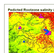
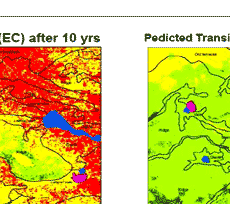
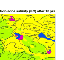
| TENTH YEARS PREDICTION OF SALINTY |
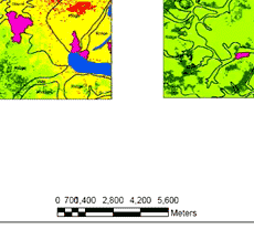
| A different situation is predicted in the transition zone (table.1) where no area would be under severe salinity but the majority of the relief units would be under high salinity levels, except for the ridge, vale and glacis which would be moderately saline after ten years time. However the glacis would be almost close to 50/50 basis as around 45% of its area would be highly saline and just above 50% would be moderately saline. Quite very small areas are predicted to be under low salinity levels for both zones. Table 2. indicate salinity severity levels in terms of the entire area, where the root-zone would have 43%, 32% and 17% of the land highly, moderate and severely saline respectively. For the transition zone the major areas are under moderate (60%) and high (36%) saline conditions with only 4% under low salinity and none under severe salinity. The prediction maps for both zones are given in figure 1. |
| Relief Unit |
Total area (ha) |
Percentage area per salinity level |
| Low salinity |
Moderate |
High salinity |
Severe salinity |
| ECe (dS/m) |
0 - 4 |
4 - 8 |
8 - 16 |
> 16 |
| Floodplain |
74450 |
0.10 |
0.67 |
24.71 |
74.51 |
| Glacis |
2106.75 |
1.27 |
9.61 |
63.96 |
25.16 |
| Lateral Vale |
3254.50 |
0.14 |
3.56 |
52.36 |
43.94 |
| New terraces |
119.00 |
0.00 |
1.26 |
32.56 |
66.18 |
| Old terraces |
556.75 |
1.21 |
10.91 |
60.44 |
27.44 |
| Ridge |
12994.50 |
10.24 |
45.47 |
37.04 |
7.26 |
| Vale |
2120.25 |
7.49 |
45.71 |
43.47 |
3.33 |
|
| Relief Unit |
Total area (ha) |
Percentage area per salinity level |
| Low salinity |
Moderate |
High salinity |
Severe salinity |
| ECe (dS/m) |
0 - 4 |
4 - 8 |
8 - 16 |
> 16 |
| Floodplain |
74450 |
0.00 |
1.71 |
98.29 |
0.00 |
| Glacis |
2106.75 |
1.34 |
53.30 |
45.35 |
0.00 |
| Lateral Vale |
3254.50 |
0.11 |
27.39 |
72.50 |
0.00 |
| New terraces |
119.00 |
0.00 |
4.41 |
95.59 |
0.00 |
| Old terraces |
556.75 |
0.31 |
22.50 |
77.19 |
0.00 |
| Ridge |
12994.50 |
6.13 |
71.86 |
22.02 |
0.00 |
| Vale |
2120.25 |
5.86 |
84.46 |
9.68 |
0.00 |
|
|
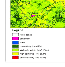
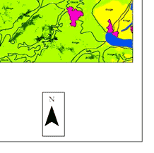
| Figure 1 : Reclassified maps for root zone for the tenth years prediction |
|