| COMPARISON OF RUNOFF RATES WITH SOIL LOSS MAP |
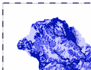
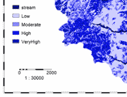
| The results of this study were correlated with the soil loss rates estimated by (Saengthongpinit, 2004), using the RMMF model (Morgan, 1995). The base simulation surface runoff predictions obtained in section 6.4 was used for this purpose. The estimated runoff rates were classified into 4 severity classes including; low runoff (0-1cm3/s), moderate runoff (1-100 cm3/s), high runoff (100-200 cm3/s) and very high runoff (>200 cm3/s). The map in figure 6-33 shows the result of the classification. The runoff class map was crossed with the soil erosion class map and it was found that 65% of the area classified as having the lowest erosion rate (up to 10 ton/ha/yr accounting for 75% of the total catchment) was found to belong to the area classified as low and moderate runoff. On the other hand, about 60% of the area classified as having the highest rates of erosion (41-60 ton/ha/yr) was found to belong to the very high and high runoff rate classes. The remaining classes did not exhibit much relation with increasing rates of runoff but only accounted for a small portion of the study area. |
|
|
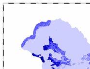
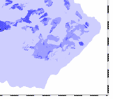
| Figure 1 : Surface runoff hazard map |
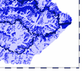
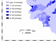
Figure 2 : Erosion hazard map (adopted from (Saengthongpinit, 2004) |
|
| References |
 Morgan, R.P.C., 1995. Soil erosion and conservation. Longman, Harlow, 198 pp. Morgan, R.P.C., 1995. Soil erosion and conservation. Longman, Harlow, 198 pp.
Saengthongpinit, C., 2004. Soil erosion assessment using revised MMF equations with special reference to terrain parameter(s) : a case study in Nam Chun sub-watershed, Lomsak district, Thailand. MSc Thesis, International Institute for Geo-Information Science and Earth Observation, Enschede, 80 pp. |
|
|
|
Development of Methodologies for
Land Degradation Assessment Applied to
Land Use Planning in Thailand |
|
|