| C-factor mapping for erosion assessment |
| The C-factor map was generated using Landsat TM data obtained on March 3, 2007. The NDVI was produced and subset to the study area. Three equations were used to calculate C-factor maps from NDVI. The results were compared with validation data, generated during fieldwork. The C-factor map derived from De Jong’s equation (De Jong, 1994). The range was between 0.020 – 0.431. Meanwhile, Van de Knijff’s equation (Van der Knijff et al., 1999) gave more C-factor values with the range between 0.135 – 1.000. The last C-factor map was derived from the relationship between training samples of C-factor values from fieldwork and NDVI. |
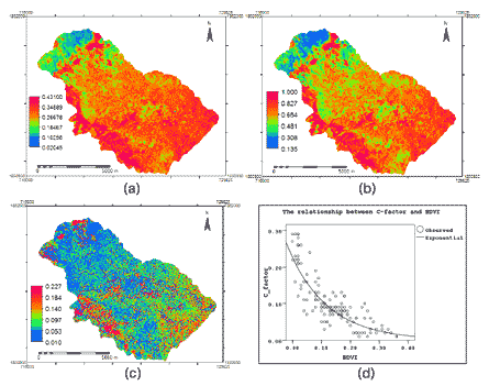 |
| Figure 1 : C-factor map 2007 derived from NDVI; (a) De Jong’s equation (De Jong, 1994), (b) Van der Knijff’s equation (Van der Knijff et al., 1999), (c) Regression equation (curve estimation) derived from the relationship between training samples of C-values and NDVI and (d) the relationship between training samples of C-values and NDVI |
|
| The C factor map was then validated by crossing C-factor maps with 125 validated C-factor values. The statistical techniques and adjusted R2 were applied to access the C-factor values estimation. The result shows that the C-factor map with the highest correlation was the one using the function derived from the relationship between C-factor training samples and NDVI (Curve estimation). It gave highest value in adjusted R2 (0.78) and C.E. (0.77) and also lower values in mean error (-0.04) and root mean square error (0.03) . The relationship between C-factor prediction and C-factor validation is shown in Figure 2 . |
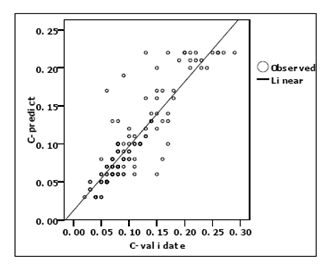 |
| Figure 2 : The relationship between C-factor prediction and validation from curve estimation |
|
| References |
 De Jong, S.M., 1994. Application of Reflective Remote Sensing for Land Degradation Studies in Mediterranean Environment, University of Utrecht, Utrecht. De Jong, S.M., 1994. Application of Reflective Remote Sensing for Land Degradation Studies in Mediterranean Environment, University of Utrecht, Utrecht. |
Van der Knijff, J.M.f., Jones, R.J.A. and Montanarella, L., 1999. Soil Erosion Risk Assessment in Italy. EUROPEAN COMMISSION DIRECTORATE GENERAL JRC JOINT RESEARCH CENTRE Space Applications Institute European Soil Bureau,
http://eusoils.jrc.it/ESDB_Archive/pesera/pesera_cd/pdf/er_it_new.pdf, pp. 58. |
|
|
|
Development of Methodologies for
Land Degradation Assessment Applied to
Land Use Planning in Thailand |
|
|


