METHODOLOGIES
|
| 1. Soil properties and land use study |
| In order to supplement and implement the runoff modelling approach conducted in this study, certain soil properties that play key roles in the generation of runoff were assessed in relation to different land use types and in relation to one another. These soil properties are including organic matter content, porosity, bulk density, saturated hydraulic conductivity, initial soil moisture content and saturated soil moisture content. Soil physical properties are the most important factors influencing the rate of water that can infiltrate into the soil. Infiltration serves as indicators for the influence of land use on the soil (Zimmermann et al., 2006) and it has also a reducing effect on the generation of runoff volume in a catchment. |
| 2. Model applications |
| In this study, The Limburg Soil Erosion Model (LISEM) was used to quantify the amount of runoff in the upper catchment that take into account effect of land cover change and also how different factors affect surface runoff. The LISEM is constructed with the PCRater dynamic modelling language (Wesseling et al., 1996) which allows great flexibility. Moreover, on a GIS level LISEM uses a raster type representation of the catchment which allows detailed representation of the processes. In case of limited data availability, the user can also choose Green and Ampt or the Holtan equation for infiltration calculation (De Roo, 2000). The results show not only the total runoff at the outlet but also the amount of sediment. |
| 3. Flood modeling |
| In order to quantify the effect of the upper catchment runoff, a combined 1D2D hydraulic model is used to model the propagation of the flow over flat terrain. SOBEK 1D2D model combines one dimensional channel flow with overland flow, which is represented by a 2D-grid of elevation information. The overall methodology of the modelling is indicated in figure. |
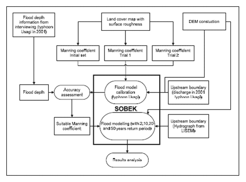 |
| Figure 1 : The overall methodology for flood modelling. |
|
| References |
 De Roo, A.P.J., 2000. Applying the LISEM Model for investigating Flood Prevention and Soil Conservation Scenarios in South-Limburg, the Netherlands. In: J. Schmidt (Editor), Soil Erosion: Application of Physically Based Models. Springer, Heidelberge, pp. 318. De Roo, A.P.J., 2000. Applying the LISEM Model for investigating Flood Prevention and Soil Conservation Scenarios in South-Limburg, the Netherlands. In: J. Schmidt (Editor), Soil Erosion: Application of Physically Based Models. Springer, Heidelberge, pp. 318. |
| Wesseling, C.G., Karssenberg, D., Burrough, P.A. and Van Deursen, W.P.A., 1996. Integrating dynamic evironmental models in GIS: The development of the dynamic modeling language. Transactions in GIS, 1: 40-48. |
Zimmermann, B., Elsenbeer, H. and De Moraes, J.M., 2006. The influence of land-use changes on soil hydraulic properties: Implications for runoff generation. Forest Ecology and Management, 222(1-3): 29-38.
http://www.sciencedirect.com/science/article/B6T6X-4HV74J4-1/2/47e54214d2f8cfa8d8777330d2a84561 |
|
|
|
Development of Methodologies for
Land Degradation Assessment Applied to
Land Use Planning in Thailand |
|
|


