| THE RECOMMENDED EROSION MODELS |
| RUSLE |
In Thailand Universal Soil Loss Equation (Wischmeier and Smith, 1965) is still extensively used. The revised USLE (Renard et al., 1991) may be better alternative than the original model. (Yazidhi, 2003)) showed that the model can be applied in Thailand situation. The revised universal soil loss equation (RUSLE) is an empirical model, modified from the USLE (Renard et al., 1997). It estimates sheet and rill erosion as a function of 6 major factors. It maintains the basic structure of USLE and computes annual soil loss in t/ha/yr as follows:
|
|
A = R*K*L*S*C*P
Where,
R: rainfall-runoff erosivity factor,
K : soil erodibility factor,
L: slope length factor,
S: slope steepness factor,
C: cover-management factor,
P: supporting practices factor. |
|
| |
Rainfall Erosivity factor |
|
| |
RUSLE assumes that when other factors are constant, soil losses from cultivated fields are directly proportional to a rainstorm parameter. Rainfall Erosivity (R) is calculated as a product of storm kinetic energy (E) and the maximum 30-minute storm depth (I30) summed for all storms in a year. This relationship (Wishmeier and Smith, 1978) quantifies the effect of raindrop impact and reflects the amount and rate of runoff likely to be associated with the rain. However, data on rainfall intensity is difficult to get in many developing nations. Relational equations are commonly used to estimate R from annual rainfall amount (X) such as the one below for Thailand (Srikhajon et al., 1994). |
|
| |
 |
| |
|
|
|
| |
Soil erodibility factor |
|
| |
Soil erodibility factor (K) measures the inherent erodibility of soil under the standard RUSLE unit plot maintained in continuous fallow (22.1 m long and has a 9 % slope) (Renard et al., 1997). The K factor integrates the effect of processes that regulate rainfall acceptance and the resistance of the soil to particle detachment and subsequent transport. It is practically the long term soil and soil profile response to the erosive powers of rainstorms; i.e. it is a lumped parameter that represents an integrated average annual value of the total soil and profile reaction to a large number of erosion and hydrologic processes. RUSLE takes into account the availability of rock fragments in estimating K. K is commonly estimated using the soil nomograph. However, for soils where the silt fraction does not exceed 70%, an algebraic approximation of Wischmeier and smith (Wischmeier and Smith, 1978) is recommended. The equation for computing soil erodibility (K) is as follows.
|
|
| |
 |
| |
|
|
| |
Where;
OM: % organic matter
S: soil structure class (1-6)
P: soil permeability class
M: (% silt +%very fine sand) *(100-clay%) |
|
|
| |
Topographic factor |
|
| |
The slope length (LS) factor represents the topographic effect in the RUSLE model i.e. slope gradient and slope length. Slope length is defined as the horizontal distance from the origin of overland flow to the point where either the slope gradient decreases enough that deposition begins or runoff becomes concentrated in a defined channel (Wishmeier and Smith, 1978). Surface runoff will usually concentrate in less than 400 ft, which is the recommended practical slope-length limit in RUSLE. Within RUSLE, separate equations are used to calculate the slope factor for areas with gradients less than 9%, and areas of equal or above 9% as shown below. |
|
| |
 |
| |
|
|
| |
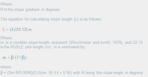 |
|
| |
|
|
|
| |
Land cover factor |
|
| |
The land cover-management factor (C) is the most important in RUSLE because it represents conditions that can easily be managed to reduce erosion (Renard et al., 1994). The C factor reflects the effect of cropping and management practices on erosion rates. It indicates how conservation affects the average annual soil loss and how soil loss potential will be distributed during cropping and other management schemes (Renard et al., 1997). It is based on the concept of deviation from a standard plot under clean continuous fallow cultivations. In RUSLE, C is computed from soil loss ratios (SLR) i.e. prior land use
(PLU), canopy cover (CC), surface cover (SC) and surface roughness (SR). Soil loss ratio is calculated as shown below:
|
|
| |
 |
| |
|
|
| |
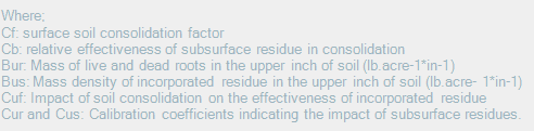
The prior land use (PLU) sub factor expresses the influence on soil erosion of subsurface residual effects from previous crops and the effect of previous tillage practices on soil consolidation. The PLU sub factor is expressed in the following relationship. |
|
| |
|
|
| |
 |
|
| |
 |
|
| |
|
|
| |
Canopy cover (CC; 0-1) sub factor expresses the effectiveness of vegetative canopy in reducing the energy of rainfall striking the soil surface. The relationship is based on the assumption that the rainfall fraction intercepted by the canopy is equal to the fraction of the land surface beneath the canopy (FC; %) and that intercepted rainfall will leave the canopy at a height (H) with a mean drop diameter of 0.1 inch (Renard et al., 1997). The canopy sub factor is computed as follows:
|
|
| |
|
|
| |
 |
|
| |
|
|
| |
The surface cover sub factor (SC; 0-1) is the single most important factor in determining soil loss ratios (SLR) values. It’s calculated as a function of ground cover (Sp; %) including crop residue, rocks, cryptogams and other non-erodible material that are in direct contact with the soil surface. Surface cover sub factor is calculated as shown below. |
|
| |
|
|
| |
 |
|
| |
Where;
b : an empirical coefficient
Ru : surface roughness |
|
| |
|
|
| |
Surface roughness affects soil erosion through the impact of residue effectiveness. The surface roughness sub factor (SR; 0-1) is estimated as a function of the surface’s random roughness (RU), which is defined as the standard deviation of the surface elevations when changes due to land slope or non-random tillage marks. Surface roughness is calculated as follows; |
|
| |
|
|
| |
 |
|
| |
|
|
| |
Where;
Ru : Random roughness value. |
|
| |
|
|
| |
The support factor (P) represents the ratio of soil loss with a specific practice to the corresponding loss with up and down slope tillage. These practices principally affect erosion by modifying the flow pattern, grade, or direction of surface runoff and by reducing the amount and rate of runoff. |
|
|
|
|
Development of Methodologies for
Land Degradation Assessment Applied to
Land Use Planning in Thailand |
|
|


