| RELATIONSHIP OF SOIL PROPERTIES WiTH DIFFERENT LAND USE/COVER TYPES |
Infiltration has a reducing effect on the volume of runoff that is generated in a catchment (Schwab et al., 1981). Certain soil properties play an important role in determining the amount of water that can infiltrate into the soil for a given rainfall event. These properties can serve as indicators on the effects of different land use/ cover types on the soils capability to take in water in the long run influencing the amount of water that will be available for runoff. Selected soil properties were therefore assessed in relation to major land use/cover types in the watershed and in relation to one another. The soil properties considered for the land use/ cover-soil relationship study include; soil organic matter content, porosity, bulk density and saturated hydraulic conductivity. In addition to these, on site infiltration tests were also conducted to asses if any relationship with the different soil properties could be observed.
|
|
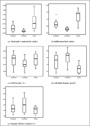 |
| Figure 1 : Variation of soil properties in different land use/ cover types. |
|
| |
|
Variability of soil properties on different land use/
cover types. |
|
| |
|
The box plots in figure 6-3 show the variation of soil properties on different land use/cover types. Hydraulic conductivity and infiltration rate appear to be high in forested areas and much lower in cornfields. Soil porosity appears to exhibit the same trend as well. On the other hand, bulk density showed highest values in cornfields and lowest in forest areas. The cultivation of maize in the area is done mainly by means of mechanised ploughing (Shrestha, 2003). This brings about
compaction which increases soil bulk density (Hillel, 1980). Thus the high bulk density in areas of corn cultivation could be attributed to land use/ cover practices. Moreover, high variation of bulk density was observed on grassland areas. This could be attributed to the fact that some grassland areas in the watershed were in the past used for maize cultivation. Organic matter content seems to show the most variation on cornfields and this could be due to the influence of management practices. |
|
|
|
|
Development of Methodologies for
Land Degradation Assessment Applied to
Land Use Planning in Thailand |
|
|


