From 513,115 km2, the total surface area of Thailand, about 3.60 Mha is salt affected soils occurring in the two regions, namely in the southern costal zone and in the Northeast plateau. The surface area of the salt-affected area in the plateau is estimated about 2.85 Mha.
Detecting and mapping salinity has been study subject for many researches, but none of the proposed techniques is declared to detect the degradation at its early stage. Next to the advantages, the limitations of the conventional Satellite remote sensing and, since over a decade already, the use of geostatistics in mapping salt-affected soils have been documented by many researchers. Remote sensing which is a relatively inexpensive detecting technique for small-scale surveys, can see the surface salinity. It is only useful to detect the last stages, when the degradation is already exhibited at the soil surface. Geostatistics, which is a precise way to represent the soil salinity distribution, needs uneconomic number of samples to model the variability.
Geopedology, which can be considered as a science and art of modelling the occurrence of soils in landscape, is vital not only in mapping soils but also in their interpretation and the followed up planning for appropriate managements.
Salinization is the dynamic process of accumulation of soluble salts in the soils. Soil salinization resulted from geopedologic/hydrologic setting is a widespread environmental problem in many places in (semi-) arid regions of the world. Although identification and large-scale mapping of salt-affected soils are essential, they are not the clue for a sustainable management. To understand the salinization process helps avoid degradation by selecting and applying the most appropriate land management practices (ref. the paper presented in Hin Hua; Understanding geopedologic setting is a clue for improving the management of salt-affected soils in Non Suang district, Nakhon Ratchasima, Thailand).
On the basis of a formulated integrated approach, where GIS-based geopedology, near surface geophysics (electromagnetic survey), modelling and multivariate geostatistics form the study components, the two studies (Soliman, 2004; Yadav, 2005) were formulated. In a GIS-based geopedologic survey the Hydropedologic setting becomes clear, which gives way to design the sampling, and the further steps of the research.
An electromagnectic device (eg., EM38) measures the ground bulk electrical conductivity or resistivity of the soil by inducting electromagnetic field and measuring the bulk electrical conductivity of the soil material, which is mainly influenced by the particles conductivity (CEC), porosity, moisture content and the salinity of soil solution. The main limitations of the EM survey lie on the reliability of the measurements where variations
of soil properties (e.g. soil moisture content and texture) have influenced the readings, and on the devised interpolator for the prediction of salinity at unsampled locations.
Objective
In the case study of Aiman (2005):
To test a methodology for subsoil salinity detection as indicator of the Salinisation process in early stages, and to evaluate it’s accuracy and resolution of presenting subsurface salinity variation over the landscape as part of the plan to combat land degradation in Nakhon Ratchasima province, Thailand.
Methodology
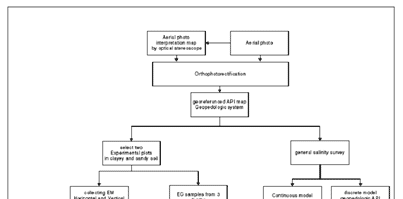
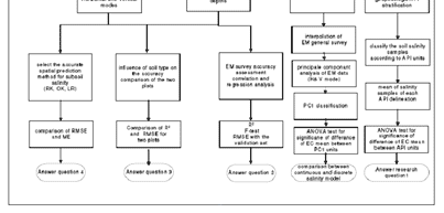
Figure 1 : Research methodology flow chart.
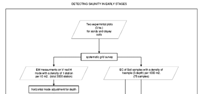
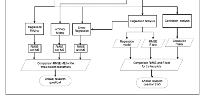
Figure 2 : Detailed flow chart for EM experimental design.
References
Soliman A., Detecting salinity in early stages using electromagnetic survey and multivariate geostatistical technique; a Case study of Nong Suang district, Nakhon Ratchasima, Thailand., in Geo-information Science and Earth Observation, Soil Information Systems for Sustainable
Land Management. 2004, ITC: Enschede. p. 100.
Development of Methodologies for
Land Degradation Assessment Applied to
Land Use Planning in Thailand