| LANDSLIDE MAPPING IN ANG KHANG USING AERIAL PHOTOS |
| Introduction |
| The most important component of any landslide hazard zonation is the preparation of a detailed landslide inventory, since in order to be able to predict the occurrence one needs to know where and how landslides have happened before. A landslide inventory is a spatial distribution of landslides, represented as points or drawn to scale, defining the type and activity of the landslides. The mapping of landslides in Ang Khang, as explained in the sections that follow, involved the use of aerial photos interpretation and ground survey (field work), including several interviews with the local population. |
| The main objective of this chapter therefore, was to produce a landslide inventory which was used as an evidence map in landslide hazard zonation . There are two basic methods of landslide hazard zonation: the direct and indirect mapping methods. The direct mapping method is a knowledge-driven geomorphic technique (Schuster 1978). During field surveys, the analyst establishes and evaluates the relationship between landslides and their geologic and geomorphic settings. The indirect mapping technique is an approach which involves the mapping of the parameters considered to be of potential effect on the occurrence of landslides. This is then followed by an analysis of all the factors contributing to the occurrence of landslides (Soeters and van Westen 1996; Suzen and Doyuran 2004). This study employed the indirect method to produce the landslide hazard zonation and eventually produce susceptibility maps. |
| Materials and Methods |
| Several materials were available during the field work preparation but some others were provided only while in the field. The field work which commenced on September 10th and ended on 10th October 2005. The materials used during the field work and in the mapping of landslides in Ang Khang are listed here under. |
 12 Coloured aerial photographs covering Ang Khang with an east to west flight path (photo scale 1:25,000 taken in January 2002) 12 Coloured aerial photographs covering Ang Khang with an east to west flight path (photo scale 1:25,000 taken in January 2002)
An IPAQ together with a GPS which contained data about Ang Khang like the district boundary, roads, rivers, and villages: secondary data provided by LDD.
A pocket stereoscope.
A Laptop for recording field data on a daily basis.
Software used to produce the landslide inventory, the factor maps and the landslide susceptibility maps was ILWIS 3.3 |
|
| Field work in Ang Khang |
| Field work activities in Ang Khang involved verifying the landslides identified during preliminary photo interpretation. Other landslides which were not on the aerial photos were also recorded. The length, width, and depth of these landslides were measured and recorded. |
| The landslide terminology used in this study was based on (Cruden and Varnes 1996) with minor modifications to suit the conditions present in Ang Khang. The modifications were necessary to identify the type of landslides and to distinguish between their various stages of activity. |
 |
 |
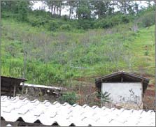 |
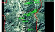
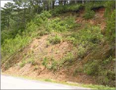
| Old Landslides observed during the field work and mapped on the aerial photo. The red lines are indicating the landslide boundaries. |
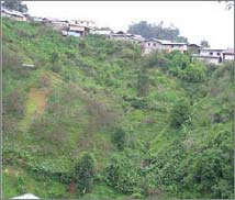
A stabilized landslide whose toe was cut off by the construction of the buildings in the foreground of the photo. |
| Figure 1 : Some of the landslides recognised in the field. |
|
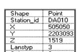
A total of 33 landslide sample points were observed in the field. Appendix: Table 2 shows the description of the sample points. Figure 5.1 shows some of the landslides observed during the field work while Figure 2 shows diagrammatic representation of the type of active landslides in Ang Khang.
In classifying landslides, emphasis was placed on the type of movement and the type of material. The movements are divided into falls, topple, slides, spreads and flows. The type of material involves debris, earth or rocks. The name of a landslide can become even more elaborate once more details are obtained. These details describe the distribution, style and the rate of movement (Cruden and Varnes 1996). |
|
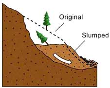 |
| Figure 2 : Showing a diagrammatic representation of the type of landslides in Ang Khang (Rotational Slides: Slumps) |
|
|
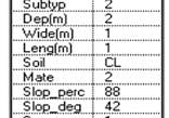
| Table 1 indicates the various descriptions used in recording the landslides observed during the field work. |
| Attribute |
Type |
Number of Observations |
| Landslide Type (Lanstyp) |
Slide |
33 |
| Sub Type (subtype) |
Rotational |
33 |
| Material (mate) |
Debris |
30 |
| Rocks |
3 |
| Lithology |
Shale |
33 |
| Soil Type (Soil) |
Clay |
5 |
| Clay Loam |
28 |
| Land Cover |
Forest |
7 |
| Degraded Forest |
18 |
| Agriculture |
9 |
| Abandoned land with Shrubs and Grass |
3 |
| Slope Percentage (Slope_perc) |
<50% |
2 |
| >50% |
31 |
|
|
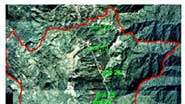
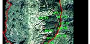
Figure 3 : Field sample points overlaid on the mosaic of Ang Khang
(together with some of the recorded attributes). |
|
| References |
| Cruden, D. M. and D. J. Varnes (1996). Landslide types and Processes. Landslides: Investigation and Mitigation. A. K. Turner and R. L. Schuster. Washington, D.C, Transportation Research Board National Research Council. Special Report 247: 36 - 75. |
| Soeters, R. and C. J. van Westen (1996). Slope Instability Recognition, Analysis and Zonation. Landslides: Investigation and Mitigation. A. K. Turner and R. L.Schuster. Washington D.C, Transportation Research Board National Academy Press. Special Report 247: 129 -177. |
| Suzen, M. L. and V. Doyuran (2004). "A Comparison of the GIS based landslide Susceptibility assessment methods: multivariate versus bivariate." International Journal of Environmental Geology 45: 665-679. |
|