| PILOT AREA II |
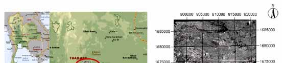
Land degradation due to drought and salinity is crucial for agricultural development in Nong Suang, Nakorn Ratcha Sima Province. Crop yields have not only decreased substantially in the recent past but the area affected by salinity has also increased which is threat to agricultural development. The area affected by salinity extends between 101o 45/ and 101o 59/ longitudes and between 15o 1/ and 15o 15/ latitudes and covers 750 sq.km of surface area. The area is characterised by tropical monsoon climate, with an average summer temperature of 40 degrees Celsius and average winter temperature of 10 degrees Celsius. Annual average rainfall is 1,000 mm, most of which falls during rainy season.
|
| Area is characterised by gently undulating to nearly level topography consisting of low and high alluvial terraces in some part of the area. Land use is paddy rice and cassava. Due to drought and salinity many agricultural areas have been abandoned. Salinity problem is in the magnitude of 25dS/m. Average ground water table is 50 cm in rainy season. |
|
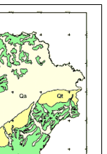
Figure 1 : Pilot area 2 Nong Suang, Nakorn Ratcha Sima Province
|
|
| Climate |
| Northeast Thailand has two main climatic seasons, the dry season, which occur from November to April. Its climate is influenced by the dry winter monsoon coming from China, while the rainy season occur from May until October, with itÆs hot wet climate generated by both the maritime monsoon passing over the Indian ocean, and the Typhoons of south China. |
| Soil climatic conditions: Moncharoen (1964) describe the dominant soil temperature regime is ōUsticö in the upland, while the ōAquicö regime dominants the low area. |
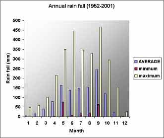 |
| Figure 2 : annual rainfall (1952-2001) |
|
| Geology |
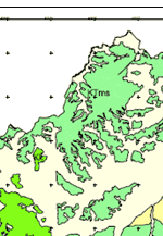
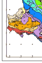
| The geological settings in northeast Thailand according to [12] is composed from: |
 Precambrian massif underlain the whole plateau. Precambrian massif underlain the whole plateau.
Mesozoic sedimentary rocks and sediments cover the massif base rock, which is called |
|
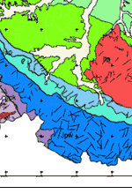
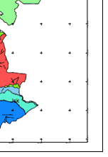
| Korat group. This group contains a Varity of sedimentary rocks like sandstone, siltstone, shale and conglomerate. Ward and Bunnag classified the Korat group into six formations, while Gardner et al 1967 gave the name ōMahaSarakhamö for the salt bearing formation), According to Imaizumi et al.(2002) the ōMahaSarakham formation is composed of clay stone, shale, inter- bedded with two or three layers of evaporates (halite, gypsum, anhydrite, carnallite, and sylvite) varying in thickness from 10 to 170 m. Figure 3. shows stone units map of Nakorn Ratchsima Provice |
Age |
: |
Formation |
Quaternary |
: |
Unnamed |
Teriary |
: |
Maha Sarakham |
|
| Cretaceous |
Upper |
Khok Kruat |
| Lower |
Phu Phan |
| Jurassic |
Upper |
Sao Khu |
| Middle |
Phra Wihan |
| Lower |
Phu Kradung |
| Triassic Middle - Upper |
Rhaetian Norian |
Nam Phong |
| Carnian Ladinian |
Hui Hin Lat |
|
The main source of soil Salinisation in northeast region is the geological formation, which includes the salt rock as part of its composition.
Generally causes of Salinisation can be summarized in to two main groups:
|
Natural Causes: The variation in ground water pizometeric pressures, which force the water to raise to the surface throw the existing faults.
Human influence: the salt mining industry is well known in the area since a long time ago, the human efforts to pump saline ground water to the surface as part of salt making industry, ion has a contribution to the rate, and spread of Salinisation. |
|
Both of the previous reasons had influence from the local geology. Solving the problem of Salinisation in the northeast Thailand depends more in understanding the natural setting more and especially focusing on the nature reaction to local communities activities. |
|
 |
Pkd |
Greyish black limestone, shale, fossiled chert, sandstone: Permian |
 |
Jbk |
Purplish silt stone, greenish sandstone, clay stone and conglomerate: Jurassic |
 |
Pn |
Greyish black limestone, taff, hornfels, chert, quartzite: Pemian |
 |
Jpp |
Greyish white sandstone, siltstone, grey or brown shale: Jurassic - Cretaceous |
 |
Ppa |
Sahle, sanstone, limestone, hornfels: Permian |
 |
Jpw |
Thick white, pink and grey Quatz sandstone, siltstone, mudstone: Jurassic- Cretaceous |
 |
Ps |
Limestone, volcanic limestone, sandstone, chert, basalt: Permian |
 |
Jsk |
Greyish red, purplish red Silt stone, sandstone, shale: Jurassic- Cretaceous |
 |
Qa |
Alluvium, sand & pebble sediment in flood plain: Quarternary |
 |
Ktms |
Reddish brown siltstone, clay stone with rock salt and potassium : Cretaceous-tertiary |
 |
Qt |
Terrace sediment, pebbles, silt, clay: Quarternary |
 |
Kk |
Brown sanstone, siltstone and shale: Cretaceous |
 |
Trhl |
Conglomerate, shale, siltstone, greywacke, limestone: Triassic |
 |
Kkk |
Lime texture siltstone, sandstone and shale, conglomerate: Cretaceous |
 |
Trht |
Mudstone, silica mudstone, sandstone, shale: Triassic |
 |
Kpp |
Thick white sandstone, siltstone, small conglomerate: Cretaceous |
 |
Trs |
Shale, sandstone, conglomerate: Triassic |
 |
Ptrku |
Unidentified volcanicĀ rock, rhyorite, andesite, taff, aggromerate, volcanic breccia: Permian- Triassic |
 |
bs |
Basalt, olivine basalt: Quarternary |
 |
PTrp |
Diorite, hornblende diorite: Permian-Triassic |
 |
|
Water bady |
|
|
|
|
| Figure 3 : Stones units map of Nakorn Rachsima |
| Source: Department of Mineral Resources |
|
|
|
Development of Methodologies for
Land Degradation Assessment Applied to
Land Use Planning in Thailand |
|
|