| SOIL SALINITY |
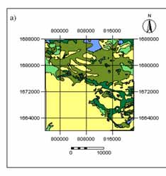
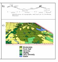
| The distribution of soil salinity in study area shows relations with local geomorphology. Salt affected soils are concentrated in lateral valleys across the area. The salt is accumulated due to t water run off, which leaches salts from upland, and precipitates it in valleys. The Salinisation process can be divided to two dynamics with different scales |
| First : The salt rock layers, which reach in some area 80-meter thickness [9], influence the ground water. Saline ground water reaches the surface through natural faults, or through bumping it for salt mining activities. This mechanism works on large scales, through the earth crust . |
| Second : salts begin to propagate upwards through the soil profile, with the help of bio-climatic, factors, which influence the evapotranspiration rate until salt spots begin to appear on the soil surface at the late Salinisation stages. The final process works in small scales along the soil profile. The interaction of the pre-described mechanisms determines the spatial pattern of salt affected soils, and its distribution in the study area. |
|
| Figure 1 : a: soil salinity map produced by Environmental science department, Thammasat university 2001.
b: cross section through the local topography after Sukchan e al.,
c: 3D view of salinity map |
|
| References |
 Imaizumi, K., Sukchan, S., Wichaidit, P., Srisuk, K., and Kaneko,F., Hydrological and Geochemical behavior of saline groundwater im phra yun, northeast Thailand. 2002, LDD: Khon kaen. p. 7-14. Imaizumi, K., Sukchan, S., Wichaidit, P., Srisuk, K., and Kaneko,F., Hydrological and Geochemical behavior of saline groundwater im phra yun, northeast Thailand. 2002, LDD: Khon kaen. p. 7-14. |
|
|
|
Development of Methodologies for
Land Degradation Assessment Applied to
Land Use Planning in Thailand |
|
|