| EROSION ASSESSMENT BY DIFFERENT MODELS |
| From the results of MSc researches it appeared that 2 erosion models namely RUSLE and RMMF, seem to be the most appropriate for Thailand. They can be applied without major constrains. RMMF can be made applicable to watershed level by incorporating flow accumulation derived from digital elevation data. But this must be validated using field data. Then only we can say which model is the most suitable one for Thailand situation since the results from the two models vary considerably. Even using one erosion model results can vary by changing some parameters. Main problem is due to unavailability of field data for validating model results. Without soil loss data it is difficult to say which model gives results which are close to the real situation. In September 2003 Dhruba Shrestha, together with Ms. Suda Swutanakoon and Mr. Sunton Ratchadawong (LDD staff, regional office in Phitsanulok) visited erosion plots in Nam Nao, which is close to Namchun Watershed. Soil loss data from these plots would be very much useful in calibrating and validating model results. Shrestha suggested to improve the existing erosion plots and also suggested to add some more plots to cater for measuring soil losses under maize cultivation, the main crop in the area. Since the erosion plots were not in good condition suggestions were made to improve them during project meetings in Bangkok. Soil loss data still needs to be collected. |
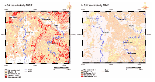 |
Figure 1 : Results of two erosion models applied in Lomsak–Lomkao area, Thailand (Shrestha et al., 2004)
|
|
|
|
Development of Methodologies for
Land Degradation Assessment Applied to
Land Use Planning in Thailand |
|
|


