| FLOOD HAZARD ASSESSMENT |
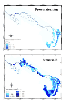
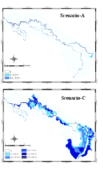
| Flood hazard study was carried out in Namchun watershed and the lowlands of Lomsak plain. For any flood hazard assessment runoff modeling is very crucial. For runoff modeling in Namchun watershed various approaches were applied (Prachansri, 2007; Solomon, 2005) such as index method, the SCS curve number method and a semi physical approach. Result of flood hazard simulation in part of Lomsak plain adjoining Namchun watershed is given in figure below. |
|
| Figure 1 : Simulation of maximum water depth in the lowlands as a result of present situation and three scenarios of land uses in the upland area in Nam chun watershed (Prachansri, 2007) |
|
| The semi-physical approach was found to be more suitable because of its simplicity and strong physical base. It is explained below. |
| Surface runoff modeling |
| that study about interception, infiltration, surface storage, evapotranspiration and routing of excess water. |
| With change in time and change in rainfall input, the height of the water level changes in each time step. The new water level is used to calculate a new wetted perimeter. In turn, this is used to recalculate the cross sectional surface parameter that is used to calculate the inflow into the stream in the next time step. |
| Lowland flood hazard modeling |
| For flood modeling of lowlands the combination of 1D2D hydraulic model can be applied for propagation of the flow over flat terrain (Prachansri, 2007). The SOBEK model (Dhondia and Stelling, 2004) combines one dimensional channel flow with overland flow, which is represented by a 2D-grid of elevation information. |
| A 1D2D hydraulic flood model requires a digital elevation model (DEM) in order to represent the topography of the downstream floodplain and to determine the direction of water flow. In case of Lomsak study area, a 10 m DEM resolution was created using 1 m contour lines and spot height obtained from Mapping division of the Land Development Department. The upstream boundary conditions were derived from the hydrological modelling (LISEM) from the upstream part. The model was calibrated using the surface roughness coefficient as calibration parameter by comparing the model result (water depth and flood extent) with field observations of the 2001 flood caused by typoon Usagi. These observations were collected during the fieldwork. In the study, the flood modelling only focuses on the flooding attributed by the Nam Chun River and not of floods caused by the Pa Sak river. |
| Surface roughness |
| In flood modelling, the resistance to flow is required to show the flood characteristics on floodplain. The resistance of flow is parameterized by the roughness coefficient. A roughness coefficient represents the effect of the channel bank and bed particles as well as from losses attributed to dynamic alluvial bed forms and vegetation of various types located along the banks and floodplain (Maidment, 1993b). The land cover map can be transformed into surface roughness values according to Manning’s coefficients (Chow, 1959). These coefficients were specified for different land cover classes. |
| Model calibration |
| The calibration process emphasizes on the different set of Manning coefficients. Three trials were decided by changing the Manning’s roughness coefficient. |
| The success of the model calibration were evaluated by comparing model results and observed data and by using objective functions including model biasness and root mean square error (RMSE). |