| MODELLING RUNOFF USING THE SEMI-PHYSICAL APPROACH |
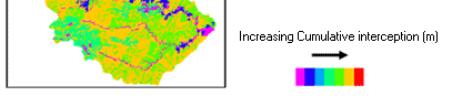
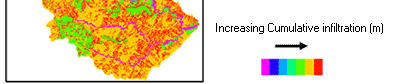
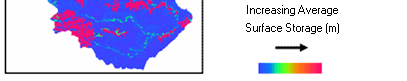
The third and final approach involved the use of several equations to model the different components of surface runoff generation and route the excess water. Unlike the previous two approaches, this approach was mainly based on the physical nature of the components involved. Figures show the simulation of the loss factors; total cumulative interception, total cumulative infiltration and average surface storage respectively.
|
| The rainfall data shows the highest rainfall was observed in the first 30 minutes of the rainfall event. However, no runoff was estimated in the first few time steps (1- 10min) as shown in time step 1. This was because much of the rain water contributed to loss factors in the model for the first few minutes into the rainfall event. Therefore, no runoff occurred until the initial losses were satisfied. Half an hour into the event, surface runoff was observed throughout the catchment occurring, at different magnitudes in different areas. At this time, the losses had been satisfied and the excess precipitation was routed over the catchment as surface runoff. In time step 60, the volume of surface runoff had gradually declined because the rainfall had significantly reduced. Although the amount of rainfall between time steps 60 and 90 was very small (0.008mm/min), runoff continued to occur because the model takes into account the accumulation of rainwater from preceding time steps in the watershed and also because of the delay factor introduced by the kinematic wave equation. The effect of the latter continued particularly along the main drainage lines from time steps 90 to 180 although rainfall had already stopped. |
|
| Figure 1 : Spatial and temporal distribution of surface runoff (time step =1min) |
|
|
| Figure 2 : Spatial distribution of cumulative interception loss |
|
| Figure 3 : Spatial distribution of cumulative infiltration loss |
|
| Figure 4 : Spatial distribution of average surface storage |
|
| |
| Notable surface runoff took place between time steps 30 to 90. As such, the model results were evaluated with respect to different land use/ cover classes in the watershed during this period. The average surface runoff rate predicted by the model during this period ranged from a minimum of 0.00 to a maximum of 0.41m3/s. The average surface runoff rate estimated for the whole area was 1.98 x 10⁻⁴ m3/s. The weighted average surface runoff rates estimated per pixel for different land use/ cover types are given in table 1. The highest volume of surface runoff was predicated for orchard plantations with an average value of 6.88x10⁻⁴m3/s and the lowest was predicted for forest areas with an average of 0.61 x 10⁻⁴ m3/s. On the whole, agricultural areas showed approximately 2 x higher values of surface runoff rates with an average of 4.78x10⁻⁴ m3/s than the non-agricultural areas having an average surface runoff value of 2.04 x 10⁻⁴ m3/s. |
| Land use/cover |
Average surface runoff (m3/s) |
| Corn Field |
3.32 x 10⁻⁴ |
| Orchard |
6.88 x 10⁻⁴ |
| Mixed Corp |
4.16 x 10⁻⁴ |
| Grassland |
3.18 x 10⁻⁴ |
| Degraded Forest |
2.34 x 10⁻⁴ |
| Forest |
0.61 x 10⁻⁴ |
|
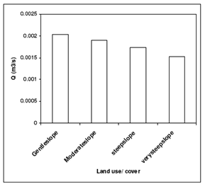 |
| Figure 5 : showing the predicted runoff rates on different slope classes |
|
The relatively lower runoff level observed in areas of corn fields can be attributed to the combination of high surface cover and surface roughness values that were assigned to the interception and surface storage components of the model respectively. This implies that very little water becomes available for runoff by the time both interception and surface storage have been satisfied irrespective of the low infiltration rates in these areas. However, this occurs only when the corn is mature and the effects of tillage on surface storage have not been worn down by rain drops which was the case during the field work period of this study. The situation would be completely different when the corn is harvested. Interception store becomes minimal and surface storage diminishes as a result of direct impact of rainfall on the bare soil. The average surface runoff for the same rainfall event in corn field areas, with these values altered increases by up to 25 x more than the previous value. This raises the average surface runoff value for agricultural areas to 3.088 x 10⁻³ m3/s making it 15 x larger than the average surface runoff rate from nonagricultural areas. This significant difference in surface runoff rates emphasizes the need for the development of conservation strategies to protect the soils in agricultural areas in the Nam Chun watershed from further degradation. |
|
| As per the (FAO, 1990) slope categorisation, the area was divided into four slope classes to assess the effects of slope gradient on the predicted surface runoff rates. The classes include gentle slopes (0-5%), moderate slopes (5-15%), steep slopes (15-30%) and very steep slope (>30%). |
| The figure shows that the gentle slopes have higher discharge than the steeper slopes. The reason for this could be that a large portion of the area classified as very steep slope belongs to the forest, degraded forest or grassland land use/ cover classes. These areas compared to the areas of agriculture practice have lower runoff rates. The use of gentler slopes for agriculture practices is therefore a good management strategy being employed in the catchment which has lower impacts on the rate of runoff. |
| References |
 FAO, 1990. Guidelines for Soil description. Food and Agriculture Organization of the United Nations, Rome. FAO, 1990. Guidelines for Soil description. Food and Agriculture Organization of the United Nations, Rome. |
|