| THE AREA (PILOT 3) - Wang Chin. Phrea Province |
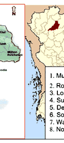
| Land degradation due to mass movement is crucial in Wang Chin area, Prae province. Deforestation of steep mountain slopes and improper land use practices enhances instability of slopes, which result in land sliding if excessive rain occurs. The Mae Suary sub–watershed area lies between 99° 25/ and 99° 38/ longitudes and between 17° 41/ and 17° 53/ latitudes and covers 250 sq.km of
surface area (Figure 1.). Elevation varies from 105 to 1,222 m asl. The area receives average rainfall of 1,125 mm, most of which falls during rainy season. August is the month with highest rain. Land use is mainly forest and shrub on the sloping area while there are some orchards on low and medium terraces of the Yom river, which passes through the Wang Chin District covering 27 km length.
Paddy areas occupy along two sides of the Yom River which was damaged by mass movement in 2001. |
|
| Figure 1 : Pilot area 3: Wang Chin, Phrae province |
|
| Climate |
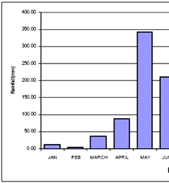
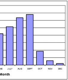
| Wang Chin is characterised by a tropical climate that is influenced by both north eastern and south western monsoons. The area experiences an annual average rainfall of 1739 mm based on 8 years (1997 to 2004, Wang Chin District) of daily rainfall records, most of which falls during rainy season (May to October) as shown in the Figure 2. |
|
| Figure 2 : Average Monthly Rainfall for Wang Chin |
|
| From the above figure, we notice a double peaked rainfall regime in Wang Chin, one in May and the other in September. The months of October to April are relatively dry months compared to the rest of the year with February being the month with least rainfall (about 10mm). Temperatures range from a minimum of about 12oC during the winter season (November to March), to a maximum of about 35oC during the summer season (May to September). |
| Geology and Geomorphology |
| The study area lies in the northern highlands of Thailand. The main geological ages of the area include Quaternary and Permian ages. The upper portion of the area comprises of Rhyolite, Phyllite and undifferentiated sandstone. The middle part of the area, which is a lateral valley, comprises of colluvial and alluvial deposits also called River and terrace gravel. The lower part of the area comprises mainly of shale and sandstone rocks (see figure 3.) |
| Wang Chin has two basic landscapes: a lateral valley in the centre and mountainous areas on either side of the valley, running from North East to South West. |
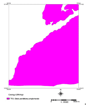 |
| Figure 3 : Geology map of Wang Chin |
|
| Soils |
| Soils in Wang Chin are classified into two main orders; Inceptisols and Alfisols. Inceptisols have profiles features more weakly developed than many of the other soils but retain a resemblance to their parent rock material. They have an umbric, mollic epipedon or a cambric horizon. A Cambric horizon is one in which the parent material has been changed into soil by formation of soil structure, liberation of iron oxides, clay formation and obliteration of the original rock structure. Mollic and Umbric horizons are both dark coloured surface horizons but Mollic horizons are typical of steppe slopes with over 50 percent of the exchange capacity dominated by base cations. Umbric horizons have less than 50 percent of the exchange capacity dominated by base cations (Bridges 1997; Buol, Hole et al. 1997). Wang Chin soils have an argillic horizon and moderate to relatively high base content (calcium, magnesium, sodium and potassium). An argillic horizon is an illuvial horizon enriched with clay to a significant extent, The Alfisols are further classified into a suborder called Udalfs while the suborder for Inceptisols is Tropepts (Bridges 1997; Buol, Hole et al. 1997). They have a soil textural classification range from Silt Loam to Gravely Loam. The moisture regime in Wang Chin is Ustic. |
| Land cover and Land use |
| The Mae Suary sub–watershed consists of five major land cover types. These include forests (both degraded and undegraded), irrigated rice, mixed cultivation, which includes vegetables of various types and other staple foods, and shrub. The land use is mainly forest and shrub on the sloping area while there are some orchards on low and medium terraces of the Yom river, which passes through the Wang Chin District covering about 27 km length. Paddy rice areas occupy the flood plain of the Yom river which was damaged by mass movement in 2001. |
| References |
 Bridges, E. M. (1997). World Soils. Cambridge, Cambridge University Press. Bridges, E. M. (1997). World Soils. Cambridge, Cambridge University Press. |
| Buol, S. W., F. D. Hole, et al. (1997). Soil Genesis and Classification. Iowa, Iowa State University Press, Ames,. |
|