| FLOODING SCENARIO |
| 2 years return period |
The results indicated that for a storm with a return period of 2 years, under present situation (present land use on upstream), the average inundation depth was 0.35 meters but at some places a maximum depth of 0.89 was reached. Only 8% of the territory was flooded at the lower part (figure 1). When the whole upstream catchment was transformed to cornfields (scenarios B and C), the maximum flood water depth downstream increased 2 times and the spatial flood extent on the floodplain increased more than 3 times. There was no flood downstream in case of the entire upland area cover by forest (scenario-A). The maximum flow velocity was highest on scenario-C (the whole catchment under corn cultivation after harvest and soil condition being bare thus no vegetation cover). However, there is small different on flow characteristics between scenario-B and scenario-C. This can be explained by the shape of hydrograph from upstream which are quite similar in term of volume of water and distributions of discharge magnitudes over time.
|
 |
Figure 1 : The spatial distribution of maximum water depth of the three scenarios
and present land use with 2 years return period.
|
|
| In most cases the flow velocity does not rise above 0.30 m/s. Only along the river bed and the road higher velocity are found especially in scenario-B and scenario-C. (see figure 2) |
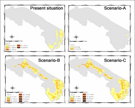 |
Figure 2 : The spatial distribution of maximum flow velocity of the three scenarios
and present land use with 2 years return period.
|
|
| |


