| LAND USE SCENARIOS |
| Although the models might not be able to accurately predict future events they may be used to simulate different land use scenarios (Hessel et al., 2003; Jetten et al., 1999). In the case of scenario,the same uncertainty in input data applies to all scenarios and one can therefore assume that the differences produced for the different simulations are in fact a consequence of the applied scenariochanges. Therefore in order to evaluate the effects of the different land use scenarios, three land cover scenarios were developed: |
 Scenario base: Present situation. Scenario base: Present situation.
Scenario A: Changing the entire catchment under forest, the values of all parameters used were converted to those used for representing forest area.
Scenario B: Changing the land use to corn cultivation before harvest, the values of all the parameters used were converted to those used for representing cornfields before harvested.
Scenario C: Changing the land use to corn cultivation after harvest, the values of all the
parameters used were converted to those used to account for cornfields after harvest and the soil being bare.
|
|
| Scenarios |
Peak discharge(m3/s) |
Change in peak discharge * |
SC |
SR |
| Present situation |
37.90 |
0 |
0.0 ** |
593,152
|
| Entire basin forested (A) |
9.27 |
-76% |
2.0 |
177,042 |
| Change from forest to cornfield before harvest (B) |
184.14 |
5X |
-2.0 |
2,183,872 |
| Change from forest to cornfield after harvest (C) |
193.93 |
6X |
-3.0 |
2,267,746 |
|
Note :
|
* Compared to present situation |
| |
** Peak time of present situation is 3 1/2 hours |
|
| Converting the results of the whole catchment into forest cover results in an overall decline in the amount of surface runoff and peak discharge from the watershed. It also increases the peak time of runoff from the catchment. The peak runoff predictions were found to be decreased by 76%, total discharge decreased by 70% and peak arrival time was delayed by two hour from present land use. In contrast, the effects of changing to corn cultivation show the opposite results of the previous scenario. For peak runoff, the predictions of the cornfield scenario before harvest were found to be 5 times greater than that of the present land use and in the case of the after harvest scenario, the peak runoff was found to be about 6 times greater than that of the present land use. The peak time decreased to 2 hour and 3 hour under cornfield before harvest and after harvest condition respectively. In scenarios B and C, total discharges were found to be about 4 times greater than that of the present land use. |
|
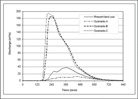 |
| Figure 1 : Predicted hydrograph for different land use scenarios. |
|
|
| This indicates that the effect of cornfield cultivation brings about an increase in the amount of surface runoff that generated large water volumes flowing out of the catchment. The extent of the overall increase in both cases shows that expanding areas of agricultural practices in the watershed could result in an extensive increase in amount of surface runoff. |
| The hydrographs shows the discharge pattern in the Nam Chun catchment as predicted by the present land use and the three case scenario studies. The hydrographs show significant changes on all scenarios. In forest scenario, the hydrograph reduced the peak runoff as well as the overall discharge pattern of the river. In contrast, the hydrographs show significant increase in the predictions of the scenario from the predictions of the present land use on changes to corn cultivation and also indicate a sharp increase in peak runoff. |
| References |
Hessel, R., Jetten, V., Liu, B., Zhang, Y. and Stolte, J., 2003. Calibration of the LISEM model for a small Loess Plateau catchment. CATENA, 54(1-2): 235-254.
http://www.sciencedirect.com/science/article/B6VCG-48SPBWM-1/2/ff6340f370a510d51967db7375eb9c66 |
| Jetten, V.G., De Roo, A.P.J. and Favis-Mortlock, D., 1999. Evaluation of field-scale and catchment-scale soil erosion models. Catena, 37: 521-541. |
|
|
|
Development of Methodologies for
Land Degradation Assessment Applied to
Land Use Planning in Thailand |
|
|


