| RESULT |
| SOIL PROPERTIES AND LAND USE |
| The box plot comparison shows a pronounced decline of the hydraulic conductivity from forested area on the top to orchard and cornfield on the bottom . Soil porosity appears to exhibit the same trend as well (panel b). In contrast, bulk density shows (panel c) highest values in cultivated areas (cornfield and orchard) while the lowest value shows in forested areas. Organic matter content shows (panel d) the highest values on forested areas and degraded forest where as the lowest value exhibits on cornfield, this could be due to the mechanical destruction of organisms effects on the abundance and activity of soil organism. |
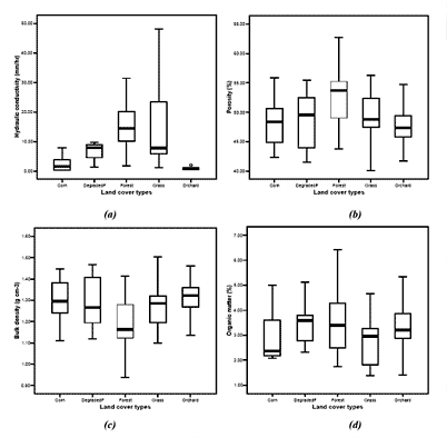 |
| Figure 1 : Box plots of variation of soil properties in different land cover types;(a) hydraulic conductivity, (b) porosity, (c) bulk density and (d)organic matter content. |
|
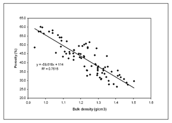
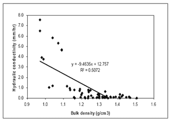
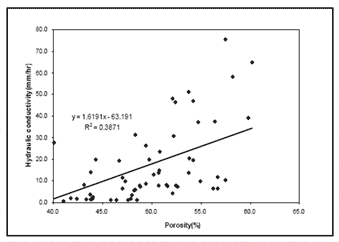
| The relationship between the different soil properties was assessed using a regression analysis. The resulting level of significant revealed that the relationship between all cases assessed was statistically significant (P<0.05). |
 |
 |
| Figure 2 : The relationship between bulk density and porosity. |
Figure 3 : The relationship between bulk density and hydraulic conductivity. |
 |
|
| Figure 4 : The relationship between porosity and hydraulic conductivity |
|
|
| Model calibration and validation |
In this study, LISEM model was evaluated using 6 selected rainstorm events. Three events serve as a calibration set. Rainfall data are available in hourly and outlet discharge. The other three storms serve as a validation set, only rainfall data were used for simulation using calibration parameters (De Roo and Jetten, 1999).
|
| The three events were selected to calibrate which includes the 060905(06 September 2005), 180905 (18 September. 2005) and 260905 (26 September 2005) events. Table 6-7 gives a summary of the event characteristic showing that peak discharges were about 37.5, 13.0 and 31.45 m3/s respectively. All events were thus of different magnitude and duration, with the 060905 and 180905 being the least rainfall intensity different. |
| Events |
Event characteristics |
| Total rainfall (mm) |
Maximum rainfall intensity (mm/hr) |
Peak discharge (m3/s) |
| Calibration |
| 60905 |
56.00 |
16.00 |
37.50 |
| 180905 |
20.00 |
18.00 |
13.00 |
| 260905 |
32.00 |
30.50 |
31.45 |
| Validation |
| 70905 |
17.50 |
10.00 |
4.20 |
| 90905 |
15.00 |
8.50 |
1.02 |
| 120905 |
29.00 |
20.50 |
15.37 |
|
| The results of the model were compared with discharge data measured from outlet of catchment. The simulated and measured hydrographs for three events are presented in the figure and table. |
| Events |
Rainfall (mm) |
Peak discharge |
| Obs (m3/s) |
Sim (m3/s) |
| Calibration |
| 60905 |
52.58 |
37.5 |
37.90 |
| 180905 |
18.43 |
13.00 |
13.40 |
| 260905 |
29.49 |
31.45 |
32.99 |
| Validation |
| 70905 |
16.60 |
4.2 |
4.72 |
| 90905 |
10.61 |
1.02 |
1.30 |
| 120905 |
26.74 |
15.37 |
23.81 |
|
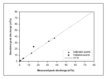 |
Figure 5 : Measured and simulated discharge in Nam Chun catchment of the three calibration
and three validation events. |
|
| References |
 De Roo, A.P.J. and Jetten, V.G., 1999. Calibrating and validating the LISEM model for two data sets from the Netherlands and South Africa. CATENA, 37(3-4): 477-493. De Roo, A.P.J. and Jetten, V.G., 1999. Calibrating and validating the LISEM model for two data sets from the Netherlands and South Africa. CATENA, 37(3-4): 477-493.
http://www.sciencedirect.com/science/article/B6VCG-3Y51V0XH/2/c047330928040c19a8cd581e7540192b |
|


