| THE PILOT AREAS |
| Pilot area I |
| In Nam Chun sub-watershed land degradation due to soil erosion and flooding are the main land degradation problems. Deforestation on steep mountain slopes and cultivationof field crops down slope has led to accelerated soil losses. In the low lands, floodingtakes place almost every year, which is caused not only by excessive rain but also due tosediment rich overland flow. |
| The Nam Chun sub-watershed area consists of a narrow valley bordered by sloping and steep hilly and mountainous land. It lies between 16° 44/ and 16°48/ latitudes and between 101° 02/ and 101°09/ longitudes and covers 67 sq.km surface area . Elevation varies from 240 to 1,509 m asl. Climate is characterized by tropical monsoon climate with annual average rainfall of 1,000 mm, most of the rain falls during rainy season. Rainy season occurs during May to October months. In the hilly and mountainous areas rainfall amount may be more than in the low lands. Natural vegetation consists of mainly fallow grass lands, dominated by Imperata cylindica. Land use in the steep mountain slopes is mainly forest; the low lands are traditionally used for growing rice in the wet season. Where irrigation water is available, such crops as mung beans, soybean and tobacco are grown after the rice is harvested. Most of the sloping and steep lands have been deforested in the last 25 years and are now used for annual crop production, predominantly maize, and locally groundnuts, as a single cash crop, sometimes followed by mung beans as a second crop. |
|
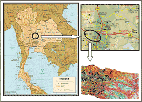 |
| Figure 1 : Pilot area 1: Namchun watershed in Lomsak, Phetchabun province |
|
|
| Mechanised downslope ploughing is the dominant land preparation practice that causes severe erosion in many areas. As a consequence, the yield has declined since the farmers started cultivating. Yields of many crops such as maize and rice have decreased. To increase the earnings of the farmers credit is given to switch to the alternative crop (sweet tamarind), which requires five to seven years to bear its first harvest. Due to heavy rain this year lots of damage to land (soil loss through landslides), peoples� properties and even human lives occurred which raises concern among land use planners and development organisations. |
| Geology and Geomorphology |
| The area mainly composed of uplifted sedimentary rocks of the Korat group in the upper catchment area. The oldest rocks are of the Huai Hin Lat formation which consists of conglomerate, sandstone and shale, partly intercalated with andisitic tuff and aggromorate. The next formation is Nam Phong which contains raddish-brown cross-beded sandstone and conglomerate. Both formations were formed during the upper Triassic period. The formation next in age is the Phu Kradung formation which consists of shale, siltstone and sandstone. This was formed in the Jurassic period and occurs along the scarp in the study area. The youngest formation of the Korat group that occurs in the study area is Pha Wihan which consists of white and pink, cross-bedded sandstone with pebbly layers in the upper beds with some intercalations of the reddish-brown and grey shale. The lower plain consists of the Quaternary colluvial and alluvial terrace deposits . |
|
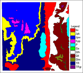 |
| Figure 2 : Geological map of the area |
|
|
| Soils |
 |
| Figure 3 : Geo-pedplogical map of the area |
|
|
The area mainly composed of uplifted sedimentary rocks of the Korat group in the upper catchment area. The oldest rocks are of the Huai Hin Lat formation which consists of conglomerate, sandstone and shale, partly intercalated with andisitic tuff and aggromorate. The next formation is Nam Phong which contains raddish-brown cross-beded sandstone and conglomerate. Both formations were formed during the upper Triassic period. The formation next in age is the Phu Kradung formation which consists of shale, siltstone and sandstone. This was formed in the Jurassic period and occurs along the scarp in the study area. The youngest formation of the Korat group that occurs in the study area is Pha Wihan which consists of white and pink, cross-bedded sandstone with pebbly layers in the upper beds with some intercalations of the reddish-brown and grey shale. The lower plain consists of the Quaternary colluvial and alluvial terrace deposits . |
|
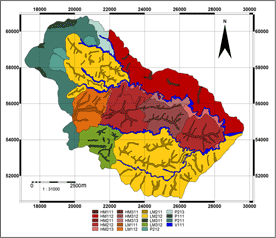
| Landscape |
Relief |
Lithology |
Land form |
Soil |
Map Unit |
| Pateau(P) |
Cuesta(P1) |
Sandstone |
Scarp |
Lithic Udorthents |
P11 |
| |
|
Colluvium |
Very steep talus |
Lithic Haplustalfs |
P121 |
| |
|
|
Steep talus |
Ultic Hapludalfs |
P122 |
| |
Escarpment(P2) |
Siltstone |
Slope facet complex |
Typic Paleudalfs |
P2 |
| Mountain(HM) |
High Ridge(HM1) |
Andesitic tuff |
Slope facet complex |
Ultic Hapludalfs |
HM1 |
| |
Moderate High Ridge(HM2) |
Andesitic tuff |
Middle slope |
Lithic Haplustalfs |
HM21 |
| |
|
|
Foot slope |
Typic Paleustalfs |
HM22 |
| |
Erosional Glacis(HM3) |
Andesitic tuff |
Middle slope |
Ultic Haplustalfs |
HM31 |
| |
|
|
Foot slope |
Lithic Haplustalfs |
HM32 |
| Low Mountain(LM) |
High Ridge |
Andesitic tuff |
Slope facet complex |
Ultic Haplustalfs |
LM1 |
| |
Moderate High Ridge |
Andesitic tuff |
Slope facet complex |
Typic Haplustalfs |
LM2 |
| |
Low Ridge |
Andesitic tuff |
Undulating |
Ultic Paleustalfs |
LM3 |
| Valley |
|
Alluvial |
Side slope |
Fluventic Haplustalfs |
V1 |
| |
|
Colluvial |
Bottom complex |
|
|
|
| Vegetation and Land Use |
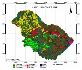 |
| Figure 4 : Land use/cover map of the area |
|
|
The dominant land use types in the study area include forest, agricultural land, shrub, grassland and residential area. Agricultural lands include rainfed annual crops, paddy rice fields with secondary crops, and orchard/ tree plantation areas such as tamarind, mango, litchi, etc. On the upper catchment area, the forest type is mixed deciduous. Owing to deforestation, degraded and disturbed forests are found on higher sloping areas. Most of the area is used for agricultural and human settlements. Farmers have encroached forest areas for cultivation of maize and other food crops. The major land use types are maize cultivation followed by beans or cabbage in the mountains and tamarind in the hilland. Most of the upper part of the catchment is covered by fallow grasslands which are dominated by the species Impecata cylindica. At the lowland, farmers mainly grow rice in rainy season followed by various crops such as tobacco, cucumber and maize in the dry period, locally being irrigated. On the levees, coconut palm, mango and tamarind are grown, which are also occupied by settlements.
|
|
|
|
Development of Methodologies for
Land Degradation Assessment Applied to
Land Use Planning in Thailand |
|
|


