| MATHEMATICAL (REGRESSION) MODEL FOR CROP YIELD ESTIMATION |
| The relationship between soil chemical properties, ground water properties and maize yield resulted the following significant (R2= 0.795 and adjusted R2=0.778) mathematical yield model |
| The equation could be applied to estimate maize yield. |
 |
Where,
MY= Maize yield (kg/ha)
WEC= Weighted electrical conductivity of root zone (dS/m)
GWD = Ground water depth (cm)
GWEC = Ground water electrical conductivity (dS/m)
CEC = Cation Exchange Capacity (me/100 gm of soil)
OM = Organic matter (%)
|
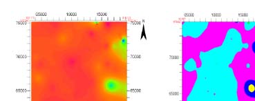
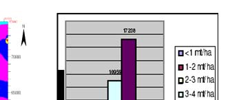
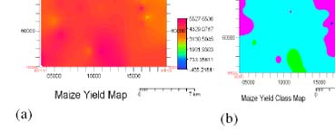
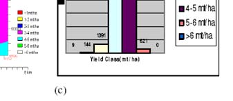
| Yield modelling with different degrees of salinity in relation to soil fertility in figure 5-14 (a) is shown that the crop yield (Maize) is decreased with increasing salinity. The pattern of yield can be compared with the salinity map where it clearly shows low crop yield in highly saline area. The maize yield class map shows crop yield 3 - 5 mt/ha obtained higher percentage of land area (28197 ha). The area under low yield (0-3 mt/ha) was estimated 1544 ha. |
|
| Figure 1 : (a) Maize yield per pixel (b) Maize yield class (c) Area under different yield class |
|
| The result in the figure shows the suitable area for the production of maize crops under different degree of salinity considering other soil factors. Therefore, it could be applied in managing salinity for the maize crops in that area. |