| CASE III - PREDICTION OF SOIL SALINIZATION USING SALTMOD IN A GIS ENVIRONMENT |
| Madyaka, M. (2008) had tried out the application of the model (SaltMod) to trace the spatial and temporal variability of soil salinity. To apply GIS and geostatistical techniques to indicate and map potentially salt-affected areas based on long term salinization predictions and agricultural practices currently applied in the study area. This aims at devising means that can help detect salinization at early stages to help devise appropriate mitigation and management plans to combat, control and prevent spread of soil salinity. |
| Objective |
| The general objective of the study is to try out the application of the model (SaltMod) to trace the spatial and temporal variability of soil salinity. To apply GIS and geostatistical techniques to indicate and map potentially salt-affected areas based on long term salinization predictions and agricultural practices currently applied in the study area. This aims at devising means that can help detect salinization at early stages to help devise appropriate mitigation and management plans to combat, control and prevent spread of soil salinity. |
| Methodology |
| The general idea of the research is to implement an integrated approach including various methods towards understanding salinization process for better management of salt affected soils. However implementation of such an approach including data acquisition requires a more considerable time than the six months duration allocated for the research. Therefore this present research focuses mainly on the modelling stage using SaltMod in a GIS environment. |
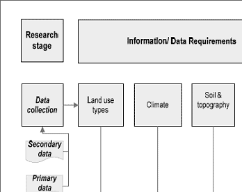
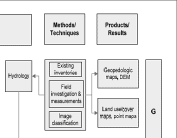
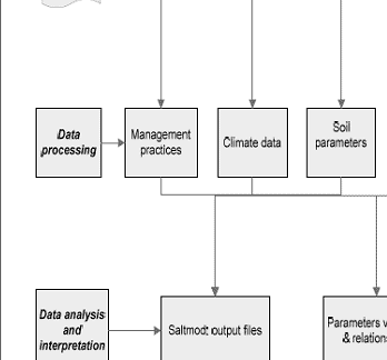
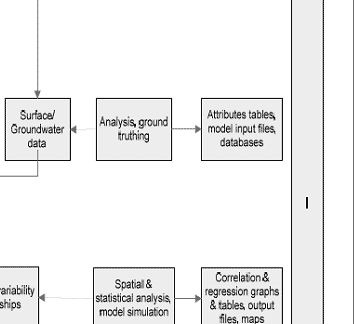
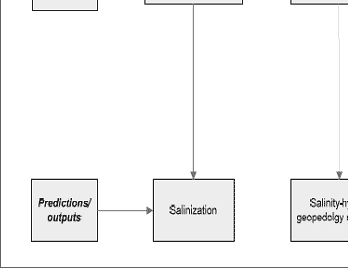
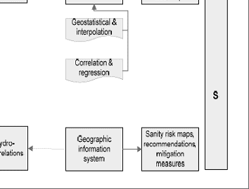
Methodology included data collection of soils and topography, land use types, climate and hydrology. Using existing inventory, field investigation and measurement and image classification to produce maps. After collection all data was processed by analysis and ground truthing to get attribute tables, model input files and databases. In the mean times several techniques of statistics were used. Data then was analysed and interpreted by SaltMod to have salinization, salinity/geopedology/hydrology relation and finally to produce salinity risk map, recommendation and mitigation measures Figure 1 summarizes a general approach followed for the accomplishment of the study.
|
|
| Figure 1 : General methodological approach (Adopted from Zinck) |
|
| References |
 Zinck, J.A., (1990) Soil survey : epistemology of a vital discipline. In: ITC Journal, (1990) 4, pp. 335-351 also published as inaugural address, 1990. Zinck, J.A., (1990) Soil survey : epistemology of a vital discipline. In: ITC Journal, (1990) 4, pp. 335-351 also published as inaugural address, 1990.
|
|