| CONCLUSION |
Some selected measured soil salinity and fertility variables (EC, pH, CEC and OM) were used to estimate their variation in geopedologic units at “relief type” and at “landscape” levels, and also their spatial variation and dependency to estimate the area affected by salinity. Soil salinity and soil fertility varied significantly within and between geopedologic units at “relief type” and “landscape” levels. Moving average gave best interpolation result in salinity and fertility modelling. PS123 simulates crop yield that correlates significantly with farmers yield. This was not true for the case of CropSyst. Both models simulate crop yield with different degree of salinity (sensitivity analysis).
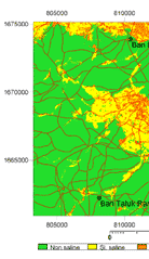
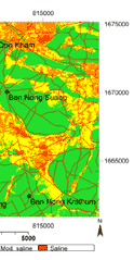
Now a days, the development of GIS and remote sensing based models are used in various fields of studies. The GIS and remote sensing tools and techniques are commonly applied in natural resources management. These were also applied in order to compare the results obtained from the deterministic models. Result of a case study of applying image transformation by means of band rotation to enhance soil spectral reflectance and combining the result in geopedologic image interpretation is shown in figure. |
|
|
Figure 1 : Classification of saline soils using image transformation, DEM and geopedologic interpretation
(Shrestha et al., 2005) |
|
|
| References |
 Shrestha, D.P., Soliman, A.S., Farshad, A. and Yadav, R.D., 2005. Salinity mapping using geopedologic and soil line approach, 26th Asian Conference on Remote Sensing, Hanoi, Vietnam, pp. 6. Shrestha, D.P., Soliman, A.S., Farshad, A. and Yadav, R.D., 2005. Salinity mapping using geopedologic and soil line approach, 26th Asian Conference on Remote Sensing, Hanoi, Vietnam, pp. 6. |
|
|
|
Development of Methodologies for
Land Degradation Assessment Applied to
Land Use Planning in Thailand |
|
|