| SOIL EROSION ASSESSMENT |
The annual soil loss predictions using data from 2007 ranges between 0 and 61 tons/hectare. Average soil loss was highest (26 tons/hectares/year) in agriculture area and lowest soil loss rate was found in forest area (0.99 tons/hectare/year). For degraded forest, grassland and orchard, the soil loss rates were 1.47, 5.39 and 8.76 tons/hectare/year respectively. These results proved that vegetation cover strongly influenced erosion process. Due to high vegetation cover such as in forest and degraded forest area, annual soil loss rate seems to be low, conversely in agriculture area more erosion because of less vegetation cover. Although orchard area had more canopy cover as compared to degrade forest or forest area but ground cover was low because farmers frequently remove grasses. This reason caused more erosion in orchard than degraded forest. For grassland, it depended on prior land use/cover types before. It gave less soil loss rates because some areas the farmer was not removed the residues after harvesting and let the grass growth in the areas.
|
| Land use class |
Area in percent |
Soil loss (t/h/y) |
SD. |
| Forest |
12.87 |
0.99 |
0.27 |
| Degraded Forest |
34.04 |
1.47 |
0.55 |
| Agricultrure |
25.32 |
26.06 |
13.52 |
| Grassland |
11.70 |
5.39 |
3.63 |
| Orchard |
16.07 |
8.76 |
0.51 |
| Total |
100 |
|
|
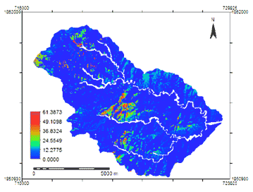 |
| Figure 1 : Soil loss map (Suriyaprasit, 2008) |
|
The soil loss map then was classified into erosion prone areas using threshold values adapted from literature (Morgan, 1995; Singh and Phadke, 2006). Five classes were made: very slight (1-4.99 tons/hectares/year), slight (5-9. tons/hectares/year), moderate (10-24. tons/hectares/year), severe (25- 44.99 tons/hectares/year) and very severe (> 45 tons/hectares/year). The tolerance of soil loss rate that agriculturist should be concerned was more than 10 ton/hectares/year (Morgan, 1995). This threshold was applied to Namchun watershed for the difference between slight class and moderate class. The erosion prone areas map of Namchun watershed 2007 is shown in Figure 2 .
|
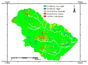 |
| Figure 2 : Erosion prone areas classified from soil loss map (Suriyaprasit, 2008) |
|
| Land use class |
Soil loss rate (t/h/y) |
Erosion prone areas |
| Forest |
0.99 |
Very slight |
| Degraded Forest |
1.47 |
Very slight |
| Agricultrure |
26.06 |
Severe |
| Grassland |
5.39 |
Slight |
| Orchard |
8.76 |
Slight |
|
| It was cleared that agriculture areas were high erosion level. They fell into severe class meanwhile orchard and grassland were slight class. Conversely, forest and degraded forest were found lowest erosion level (very slight). Overall areas had average 20.22 (tons/hectares/year) of annual soil loss rate. It illustrated more than tolerance soil loss value 10 (tons/hectares/year) and fell in moderate class. |


