| DOI ANG KHANG, CHIANGMAI PROVINCE (Pilot area 4) |
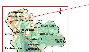
| Located on Tanaosri Mountain, Ang Khang is just five kilometers from the Thai-Burmese border. Ang Khang lies between 99° 03� and 99 ° 04� East longitudes and between 19 ° 51� and 19 ° 55� North latitudes. Situated 160 kilometres north of Chiang Mai (40 km from Fang district) and 1,400 meters above sea level, Doi Angkhang is cool all year round. The weather not only allows the growth of temperate plants, but it also attracts thousands of visitors each year especially during the cool winters (November to February). Land use in the past consisted of shifting cultivation by local inhabitants, which is now prohibited. Because of strict government policy, dense forests exist in some areas while it is degraded elsewhere. The name Doi Ang Khang was derived from a northern dialect meaning a bowl which is due to the physiography of the area that has steep mountain ridges stretching about 5 km in length and 3 km in width forming a bowl in the centre. |
| The Royal Agricultural Station Ang Khang is situated 1,400 meters above sea level in Mae Ngom sub district, Phang district, Chiang Mai Province in Northern Thailand (Figure 1.). The research station covers a total area of about 37.49 km2 with a population of approximately 2,785 people from 6 villages; Ban Luang, Ban Khum, Ban Pangma, Ban Khodong, Ban Paka and Ban Norlae. |
|
| Figure 1 : Ang Khang District (with the road network) in Northern Thailand. |
|
| Climate |
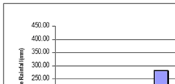
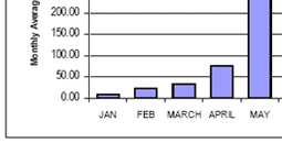
| The average temperature for the region is about 17.7 degrees Celsius with an average annual rainfall of about 2,075 mm calculated for a period of 16 years (1989 � 2004, Ang Khang Station). Maximum temperatures are in the high of 32 degrees Celsius (average maximum) in April and while minimum temperatures are as low as -3 degrees Celsius in January which causes frost. The rainfall season lasts from July to November although a considerable amount of rainfall is received in May (Figure 2.). August is the month with the highest amount of rainfall with an average of about 400mm. The figure below shows the average annual rainfall of Ang Khang. |
|
| Figure 2 : Average Monthly Rainfall for Ang Khang |
|
| Geology and Geomorphology |
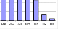
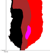
| Ang Khang is dominated by sedimentary rocks of different ages which are Quaternary and Permian. The North-eastern side of the study area is dominated by Carboniferous lower rocks, which include Sandstone, Greywacke and Shale. The mid-section comprises of carboniferous upper rocks. They comprise of Sandstone, Shale, and Conglomerates. Between the mid-section running from North to South and the Western section are small areas with Quaternary rocks. These rocks are characterised by gravel and sandstone. Rocks of the Permian age comprising of limestone dominate the Western section of the study area. Unfortunately the geology of the area on the extreme Western section � running from North to South of the study area, is unknown and thus classified as so. |
|
|
| Figure 3 : Geology map of Ang Khang |
|
| |
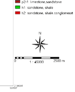
| In Figure 3 the codes q, u, p2, h1 and h2 refer to the Geological ages of the study area. T Upper, and lower respectively. The legend of these codes is given in Table 1. |
| |
| Ang Khang can be described as an area with a complex geomorphology comprising of sinks holes of Karst landforms mostly in the centre part of the study area. In the past, area used to be composed of steep mountain slopes but they were eroded to leave a bowl like shape. What is left are mountain slopes on the Eastern and the Western sections of the study area and a Piedmont in the middle (Figure 3.6). Ang Khang is also described as a relatively high terrain with elevation ranging from 1040m to 1920m above sea level. |
|
| Age |
Symbol |
Description |
| Neozoic |
Quaternary (Holocene) |
q |
Fluvial deposit and colluvium |
| Paleozonic |
Permian (lower-middle) |
p2-1 |
Limestone |
| Carboniferous (upper) |
h2 |
Sandstone, shale, chert, greywacke, conglomerate |
| Carboniferous (lower) |
h1 |
Sandstone, greywacke, shale |
|
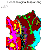
| The Geology map is referred to as the Geopedological map because a Pedological approach was used in the preparation of the map. The procedure involved aerial photo interpretation and screen digitizing in ILWIS 3.3 version. |
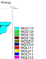
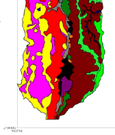
| Landscape |
Relief Type |
Lithology |
Landform |
Symbol |
| Mountain of predominantly Shale |
Ridge |
Residumm and colluvium from sandstone |
Slope Facet complex |
MOS111 |
| Residumm and colluvium from Phyllite and some shale |
Slope Facet complex |
MOS121 |
| Residumm and colluvium from shale |
Summit Shoulder complex |
MOS131 |
| Black_foot slope complex |
MOS132 |
| Hill |
Residumm and colluvium from shale |
Slope Facet complex |
MOS211 |
| Vale |
Alluvio_colluvium |
Bottom_side complex |
MOS311 |
| Mountain of predominantly Limestone |
Hill |
Limestone with associated with residumm from shale |
Slope Facet complex |
MOL111 |
| |
Tower Karst |
Limestone |
Slope Facet complex |
MOL211 |
| |
Polje (undulating to rolling surface) |
Residumm and colluvium derived from shale associated with limestone |
Sinkhole |
MOL311 |
| Piedmont |
Hill |
Residumm and colluvium derived from shale associated with limestone |
Slope Facet complex |
Pi111 |
| Tower Karst |
Limestone |
Slope Facet complex |
Pi211 |
| Erosional glacis |
Colluvium over residumm derived from shale |
Slope Facet complex |
Pi311 |
| Polje (gently sloping surface) |
Colluvium over residumm derived from shale associated with limestone |
Sinkhole |
Pi411 |
| Vale |
Alluvio_colluvium |
Bottom_side complex |
Pi511 |
|
|
| Figure 4 : Geo-pedology map of Ang Khang |
|
| Soils |
| Soils in Ang Khang consists of two main Orders (Inceptisols and Alfisols). The soil subgroups names of Ang Khang include Fluverntic Eutrudepts, Lithic Eutrudepts, Oxyaquic Eutrudepts, Rhodic Paleudalfs, Typic (Mollic) Paleudalfs, Typic Hapludalfs, Typic Paleudalfs, Ultic (Mollic) Hapludalfs, Ultic Eutrudepts, and Ultic Hapludalfs. |
| According to (Bhubharuang 1980),the soils found in the valleys of Ang Khang are of a sandy loam texture derived from alluvium material. He also discussed that the mountain of predominant shale have soils of clayey texture derived from colluvio- alluvio material while the mountain of predominantly limestone associated with shale rock types have soils of a clayey texture and are red in colour. |
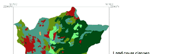
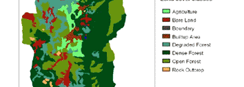
| Land cover / Land use |
| Shifting cultivation was the traditional farming system in the highlands of northern Thailand which involved indiscriminate slashing and burning of available vegetation to create land for cultivation. It was appropriate as long as the highland population was small and an abundance of land per farm owned by a family permitted long fallow periods. But rapid population growth, (caused mainly by migration from the lowlands of Thailand, Burma and Laos and high birth rates) led to a rapid decline in the amount of land available to each family. With the increasing scarcity of land, fallow periods became shorter and marginal and forested areas were turned into agricultural land (Schubert., Backhaus. Et al. 1986). |
|
|
| Figure 5 : Land cover map for Ang Khang obtained from aerial photo interpretation (2002) |
|
| |
| In the late eighties with the establishment of the Royal Agricultural Station, the slash and burn system which was considered exploitive has been eliminated (Schubert, Backhaus et al. 1986). This has enabled the hill tribe people to settle down on permanent lands and practice subsistence farming using modern agricultural techniques and profitable crops introduced by the Royal Agricultural Station in Ang Khang. The crops grown include temperate vegetables, flowers, fruits, forest plants including various kinds of bamboo, Chinese tea, linseed etc. The land cover map (Figure 5.) was prepared from aerial photo (2002) interpretation. |
| |
| |
|
| References |
 Bhubharuang, B. (1980). Soil Characterization and Land Potential assessment of Ang-Khang Range, Chiangmai. Bangkok, Kasetsart University,. Bhubharuang, B. (1980). Soil Characterization and Land Potential assessment of Ang-Khang Range, Chiangmai. Bangkok, Kasetsart University,. |
| Schubert., C., C. Backhaus., et al. (1986). Farming Systems-Oriented Crop Research. Berlin, Technical University of Berlin. |
| Udomsri, S. 2006, Application of Computer Assisted Geopedology to Predictive Soil Mapping and Its Use in Assessing Soil Erosion Prone Areas: A Case Study of Doi Ang Khang, Ang Khang Royal Agricultural Station, Thailand. MSc. Thesis, ITC, Enschede, The Netherlands. 119 p. |
|
|
|
Development of Methodologies for
Land Degradation Assessment Applied to
Land Use Planning in Thailand |
|
|