| FLOOD HAZARD MAPPING |
| Flood hazard is the probability of occurrence of a potentially damaging flood event of a certain magnitude within a given time period and area (Brooks, 2003). In this chapter, flood hazard zonation maps was done from the results of flood model simulation applying rain storms of different return period. A different degree of hazard was assigned to each flood frequency. Five categories of flood hazard were established for each scenario: |
 Areas with high flood hazard: high frequency floods – return period 2 years Areas with high flood hazard: high frequency floods – return period 2 years
Areas with medium flood hazard: medium frequency floods – return period 10 years
Areas with low flood hazard: low frequency floods – return period 20 years
Areas with very low flood hazard: very low frequency floods – return period 50 years
Areas without flood hazard
|
|
| Figure 1 shows the flood hazard zonation for each scenario, for the present situation. The high flood hazard covers 31% of the area when the whole upstream catchment area is transformed into corn cultivation (scenarios B and C). In contrast, it became smaller in high flood hazard area if the upland area converted to forest. Medium flood hazard (10 years return period) covers 36% of territory in present situation, scenarios-B and scenarios-C respectively. In scenarios-A the effect was only 28% of the area. The area under low flood hazard (20 years return period) covers only 3, 3, 2 and 1 km2 for present situation, scenario-A, scenario-B and scenario-C respectively. This can be concluded that the flood hazard was reduced if upstream became forest. In contrast, when upland area is converted into agriculture area, the flood probability will increase and also flood hazard area. |
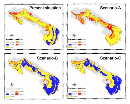 |
Figure 1 : Flood hazard mapping of the three scenarios and present land use.
|
|
References :
Brooks, N., 2003. Vulnerability, risk and adaptation: A conceptual framework, Tyndall Centre for Climate Change Research, Norwich.
|
|
|
Development of Methodologies for
Land Degradation Assessment Applied to
Land Use Planning in Thailand |
|
|


