| ASSESSING CRITICAL ZONES FOR EPHEMERAL GULLY FORMATION |
| Sensitive areas for ephemeral gully formation were calculated by using slope, catchment area and flow width. The range of sensitive areas was between -0.0550 to 2.4457. These sensitive areas then were classified by using threshold 0.72 into two classes; gully erosion and no gully erosion. According to land use/cover classification map of 2007, most of the critical zones areas were found in agriculture areas which are located in the upper part, central part and bottom right part of study area Field studies also revealed that agriculture areas really have a lot of gully erosion. However in forest areas especially plantation forest were also found gully erosion because of less vegetation cover and distance between the trees quite far. |
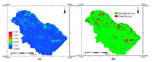 |
| Figure 1 : Sensitive areas (a) and critical zones (b) |
|
| For validation, critical zone maps were crossed with 20 gully erosion validated. Contingency matrix was done and showed overall accuracy of 65% for predicting gully erosion. This result explained that critical zones with the threshold 0.72 seemed to be acceptable index for prediction the gully erosion formation. However, because of inaccessible areas, the lack of sufficient validation points was a limitation. |
| Land use class |
|
Reference from fieldwork
Gully Erosion |
Total |
| Critical zone |
Gully |
13 |
13 |
| No Gully |
7 |
7 |
| Total |
|
20 |
20 |
|
| Overall accuracy = (13/20) x 100 = 65% |
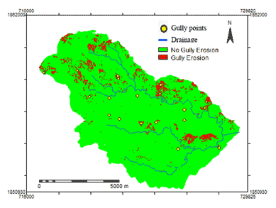 |
| Figure 2 : Gully erosion formation prediction with validated gully erosion points |
|
| Most of the study area fell on very slight (83.02%). The other areas was classified into slight (6.12%), moderate (7.60%), severe (2.79%) and very severe (0.47%) level. The gully erosion formation area was 5.53% and without gully erosion formation 94.47% of study area. |


