| MODELLING RUNOFF |
| Runoff is a dynamic process that is dependant on factors that vary both spatially and temporally. In order to evaluate the rate at which it is generated and how different factors in a catchment affect it, a modelling design in a GIS provides an ideal environment. Such an approach allows the storage, integration, analysis, and maintenance of large environmental data sets. It provides an efficient, cost effective technique that offers possibilities to investigate factors that influence the rate of runoff over a large area. The information attained can be used to simulate the effects of certain decisions on catchment management practices to prevent for instance excessive runoff that may lead to a number of problems. This study therefore considers, a modelling approach in a GIS environment as the most effective method to assess the rate at which runoff occurs over the study area and the factors that influence it. |
PCRaster, an open source, GIS software developed by the PCRaster research and development team in the Department of Physical Geography, Faculty of Earth Sciences at Utrecht University in the Netherlands (Burrough et al., 2005) was selected for use in this study. Through the use of PCRaster�s dynamic modelling language, a researcher is able to integrate equations from different sources that describe the mechanisms of the components involved in surface runoff generation. It allows the researcher to select modelling approaches that are not only suited for the objectives of a particular study but also, approaches that require input parameters that are obtainable or measurable within the time span of a study. This was a particularly important reason for selecting PCRaster for this study as, surface runoff modelling had not been done in the area before (imposing restrictions on the use of existing data) and, the data collection period of the study was limited (imposing restrictions on the amount of data that can be collected). In addition, since the main aim of this research was to assess the impacts of changes in land-use and land-cover on the rate of surface runoff, the application of a spatially distributed modelling approach, which PCRaster offers, was imperative to meet the objectives of the study.
|
Three different modelling approaches were used in PCraster to model runoff in the Nam Chun watershed. The first and second methods were empirical based approaches that describe the runoff process based on empirical assumptions. The first one was selected because of it can easily be employed and it provides an indication of whether there is a problem that needs further investigation. The second approach was also selected because of its simplicity in its data requirement but also because of the fact that it considers the influence of land use/ cover changes in the derivation of the parameters (CN) used to compute excess precipitation. The third approach was more physical based and involved the integration of equations, from different sources, that describe the different components involved in the runoff process. This approach was selected because of its physical basis. Its predictions are based on the physical laws that govern the surface runoff process and thus its results are likely to be more accurate and because it also considers the effects of land use/ cover changes on the generation of surface runoff. The following sections give brief descriptions on the methods employed.
|
|
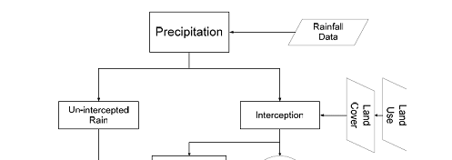
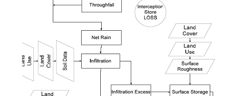
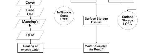
| Figure 1 : Flow chart showing the structure of the surface runoff model used |
|
| Model Parameterisation |
| Environmental models depend on one or several types of input parameters as is the case with the model used for this study. Two types of parameters are involved in this modelling approach: |
| 1. physical parameters giving information on the physical structure of the catchment including parameters derived from the DEM and |
| 2. process parameters including interception, infiltration and surface storage |
|
| that in combination influence the amount of runoff that is generated from the rainfall data used as input in the model (Kirkby et al., 1987). |
| To define the mathematical equations used to describe the processes, the parameters need to be quantified. This is known as model calibration. In some cases these parameters are measurable in the field and these field values can be used for calibration purposes (Kirkby et al., 1987). In this study, this was not possible for most of the parameters due to lack of time and resources. Most of the parameter values used were derived from literature values using information on the soil and land use/ cover characteristics of the watershed. To check the model results, discharge measurements were taken at a sub-catchment for a rainfall event. |
| References |
 Burrough, P. et al., 2005. PCRaster Home Page. Utrecht University, Utrecht. http://pcraster.geog.uu.nl Burrough, P. et al., 2005. PCRaster Home Page. Utrecht University, Utrecht. http://pcraster.geog.uu.nl |
| Kirkby, M.J., Naden, P.S., T.P.Burt and D.P.Butcher, 1987. Computer simulation in physical geography. Wiley & Sons, Chichester etc., 227 pp. |
|
|
|
Development of Methodologies for
Land Degradation Assessment Applied to
Land Use Planning in Thailand |
|
|