home
land degradation
project outcome
Gallery
Flooding
Flood Hazard Assessment
Pilot Area
• The Pilot Areas
• Climate
• Cover factor (C) estimation
• Digital terrain analysis
• Relationship between soil properties
• Relationship of soil properties with different land use/cover types
Methodology
• Methodologies
• LISEM
Results
• Result Soil Properties and Land Use
• Runoff rate for different land cover types
• Model calibration and validation
• Sensitivity analysis
• Land use scenarios
• Rainfall size scenarios
• Flooding Scenario - 2 years return period
• Flooding Scenario - 10 years return period
• Flooding Scenario - 20 years return period
• Flooding Scenario - 50 years return period
• Summary tables for each flood characteristic
• Flood hazard mapping
• Conclusions and Recommendation
Erosion
Erosion Assessment
Pilot Area
• The Pilot Areas
• Climate
• Cover factor (C) estimation
• Digital terrain analysis
• Relationship between soil properties
• Relationship of soil properties with different land use/cover types
Methodology
• Methodologies
• Erosion Models
Result
• Results
• C-Factor Mapping for erosion assessment
• Soil erosion assessment
• Assessment of land use/cover change effect on soil erosion
• Assessing critical zones for ephemeral gully formation
• Erosion Assessment by Different Models
• The recommended erosion models
• RMMF
Landslide
Case I
• Landslide hazard assessment
• The area (Pilot 3)
• Landslide Mapping in Wang Chin using digital image analysis Techniques.
• Results
• Discussions
Case II
• Doi Ang Khang (Ang Khang) (Pilot area 4)
• Landslide mapping in Ang Khang using aerial photos
• Landslide Inventory Mapping
• Landslide modelling and Susceptibility mapping
• Landslide Susceptibility Maps from the three Scenarios (models)
• Comparison between Ang Khang and Wang Chin (with respect to weights of evidence modelling using morphometric parameters)
Salinization
Case I
• Pilot area II
• Soil salinity
• Salinization
• Geomorphology
• Soils
• Geopedologic map
• Results
Case II
• CASE II - The study of Yadav, R.D. (2005),
• Methodology
• Crop Simulation Model
• PS 123
• Results
• Mathematical (Regression) Model for Crop Yield Estimation
• Conclusion
Case III
• Case III
• Modeling Salinization
• Geostatistics and Interpolation (GIS and Kriging)
• Model Simulation and Prediction of Salinity
• Simulated Depth to water table
• Tenth Years Prediction
• Twenty Years Prediction
• Conclusion
Runoff
• Surface Runoff
• Methodology
• Modelling Runoff
• Modelling Runoff Using Empirical Approach
• Modelling runoff using the Semi-physical approach
• Estimation with the Curve Number Method
• Results and Discussion
• Generation of Scenarios
• Comparison of runoff rates with soil loss map
• Conclusions
• Presentation of papers based on project work at international
• Workshop in Lomsak
• Hua Hin seminar
• Training of LDD staff
• GIS and RS based predictive soil mapping
• Soil erosion assessment
• Landslide hazard assessment
• Flood hazard assessment
• Soil salinity study
• List of completed MSc. theses on project
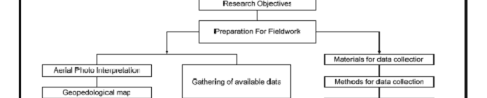
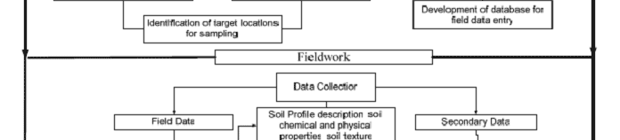
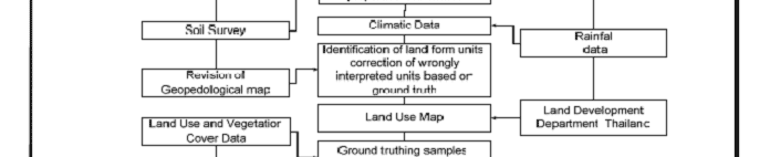
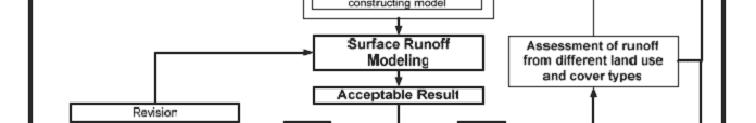
METHODOLOGY
Figure 1
: Flow chart showing the research approach of the study
Development of Methodologies for
Land Degradation Assessment Applied to
Land Use Planning in Thailand
^go to top